When Angkor Wat was discovered in the 16th century, the awe-struck explorers speculated it was built by the Romans or Alexander the Great. But the vast ruins belong to the Khmers, whose empire once ruled over Southeast Asia for 500 years, from the 9th to the 15th century.
The Khmer people, which still comprise 95% of Cambodia’s population, are an ancient ethnic group, likely a confluence of Chinese and Indian traders who settled along the way. Archeologists believe the area was inhabited as far back as 4200 BC, if not longer. Remarkably, pottery found in prehistoric caves has similarities to pottery still produced by Cambodians today.

Angkor Wat
The Khmers invented the first alphabet in the region, descending from Sanskrit, and later adopted into the Thai and Lao scripts. The oldest stone inscription in Angkor date back to the 7th century and contains one of the first uses of the number 0. Also among the first to use bronze, they developed a sophisticated irrigation system, built expansive libraries within their temples, and invented the first healthcare system in the world.
At its height, the capital city was home to a million people, about 1% of the world’s population at the time. The empire stretched to modern-day Thailand, Laos, Vietnam, Myanmar, and as far north as southern China.
The Birth of an Empire
In 790, the powerful Javanese court appointed a Khmer subject to act as a de facto ruler over their rival, the Chenla Empire, which had weakened into separate city-states. Aristocratic by birth and a revolutionary by heart, he quickly built an army and seized cities as he traveled north. Upon discovering the Kulen Hills and believing it to be the mythical Mount Meru, home to the Hindu gods, he declared independence from Java. In an elaborate ceremony presided over by a holy Bhramin, he proclaimed himself the devarāja, or god-king according to Hindu tradition, in 802.

Kulen Hills
Many of Angkor’s temples and monuments are symbolic of Mount Meru, a mythical golden mountain with five peaks equivalent to the Mount Olympus of Ancient Greece. It’s regarded as the center of the universe where the Hindu gods live and serves as the stairway to heaven. The Kulen Hills remain a sacred site in Cambodia.
He named himself Jayavarman II after the last king of Chenla to establish rightful succession. With his status as divine ruler cemented with symbolic power, he unified the fractured Khmer people. He solidified an empire not just through military campaigns, but also through alliances, land grants and marriages. He founded the city of Harihalaya, southeast of present-day Siem Reap, and made it the new capital.
The First Hydraulic City
In 877, Indravarman I came to the throne, ruling over an already strong and consolidated empire. He built the first significant structures in Angkor, including the Preah Ko and Bakong temples. Laying the foundations for future kings, his extensive building program included the Indratataka, a baray or reservoir, that could store up to 7.5 million cubic meters of water.

Bakong Temple
Constructed of sandstone, the Bakong took the shape of a stepped pyramid and served as the first state temple of Angkor.
Angkor is situated on the banks of Tonle Sap Lake, where the Mekong River flows through with waters from the Himalayas. The river has one of the most biodiverse ecosystems in the world, second only to the Amazon, and Tonle Sap has the highest concentration of freshwater fish, thriving off minerals from the Tibetan plateau.
The Khmers developed a complex water management system that prevented flooding by directing overflow from Tonle Sap into vast reservoirs. These barays filled during the monsoons, and in the dry season, a network of canals, channels and wooden gates brought water to fields of rice and other crops. As much land as possible was given to farming and they harvested three to four times a year. With its strategic location along the trade route between China and India, the empire prospered and grew.

Angkor Wat, Moat and Reservoirs
Some of the moats and reservoirs are still used. The West Baray, constructed in the 11th century to hold up to 53 million cubic meters of water - the largest man-made construction until the industrial era - is a popular lake for swimming, boating and fishing today.
Phnom Bakheng
His son and successor, Yasovarman I, moved the capital closer to the river, in between the Kulen Hills and Tonle Sap. He chose a hill 60 meters high to construct the new state temple, carving the base directly into the landscape. Surrounding Phnom Bakheng was the new royal court which would become the foundation for the new city of Angkor. He expanded the irrigation system and added the East Baray to store 37 million cubic meters of water.

Phnom Bakheng
Situated on a low, steep hill, Phnom Bakheng offers views over Angkor Wat and can swell with thousands of people at sunset.
Yasovarman I also constructed over 100 monasteries throughout the empire to serve as resting places. It’s believed this great fervor for building was caused by an illness as he is later referred to as “The Leper King.”
Koh Ker
After a brief period of instability amongst his heirs, Jayavarman IV rose to the throne in 928 and again moved the capital. This time to Koh Ker, 110 km northeast of Angkor. The building of new cities, and especially new temples, was crucial to their status as god-kings. Here, builders and artists became more experimental in architecture and sculpture.

Prasat Thom
Reminiscent of a Mayan pyramid, the large central temple rises 40 meters, is overgrown with vegetation and surrounded by crumbling walls.
Koh Ker was once only accessible to view by helicopter. Until today, mines leftover from the Khmer Rouge to the Civil War are still scattered across the jungle. Visitor walkways are marked and go no farther than 100 meters from the few structures that can be accessed. In all, about 180 surviving structures have been discovered, spread over 80 square kilometers of dense forest. Stone sculptures and elaborate motifs used to decorate the temples, but because of Koh Ker’s isolated location, they have been severely plundered by looters.

The Battle of Bhima Versus Duryodhana
These statues were stolen in 1972 and sold separately to private collectors and museums. Notice how many were usually lopped off above the feet. After decades of efforts, they were recovered from The Met, Norton Simon Museum and auction houses Christie’s and Sotheby’s. They are now housed at The National Museum in Phnom Penh.
Banteay Srei
Although constructed under the reign of Rajendravarman II (944-968), Banteay Srei was commissioned not by the king but under the authority of Yajnyavaraha, a doctor and Bhramin advisor to the royal court. Surrounding the compound are six buildings that served as rest houses and were used for meditation. Because they remained in use until the 14th century, Banteay Srei was somewhat preserved through the centuries and then carefully restored upon its discovery in 1914.

Banteay Srei
Many of the statues are replicas. The originals have either been stolen or hidden for safekeeping. In 1923, writer André Malraux tried to steal four devatas, or goddesses. Cambodia was a French protectorate then and he was stopped by custom officials.
Nicknamed “Citadel of Women,” it features some of the finest stone sculptures and wood carvings of the Khmer Empire. The unique pink hue of the sandstone is striking. Virtually every bit of wall space is intricately carved with mythical scenes from ancient Indian literature.

Banteay Srei, North Library
The walls are decorated by depictions of Krishna as he defeats his uncle, King Kashma, and Indra, god of the sky, as he showers the earth with celestial rain.
Phimeanakas
Completed by Suryavarman I at the beginning of the 11th century, Phimeanakas is unique in architecture and design. The three-tiered pyramid was built on a rectangular, slightly oblong, plan. Steep stairways lead to terraces but the tower is in ruins.

Phimeanakas
Again, what remained of the ruins was looted long ago. Only one surviving stele remains and it talks of the death of a Khmer king.
Nicknamed “Palace of Heavens,” the building’s purpose was never resolved. But legend has it that the once golden tower was the meeting place of the king and a nagi, or snake, princess. They had to meet every night before the king could retire to be with his queen. If he fails to show, his empire will fall.
Baphuon
Also under the Suryavarman I, the nearby Baphoun is built on an artificial hill. Its bottom floor measures 100 by 120 meters, ten times the size of Phimeanakas. Five terraces rise 35 meters high, excluding the tower which has collapsed.

Baphuon
Among the carvings in the inner pavilions are scenes from the Ramayana and ancient Khmers hunting.
Serving as the state temple, it was dedicated to the god Shiva. Pavilions and galleries are adorned with intricate carvings, some depicting everyday scenes of Khmer life. It was later converted into a Buddhist temple, and statues of Buddha were added.
The artificial settlement was not stable and the Baphoun had all but collapsed by the 20th century. Careful reconstruction began in the 1960s using anastylosis, a technique requiring total dismantling and then rebuilding by pieces. It was halted by the Khmer Rouge, resumed towards the end of the Civil War in 1995, and took 16 years to complete.
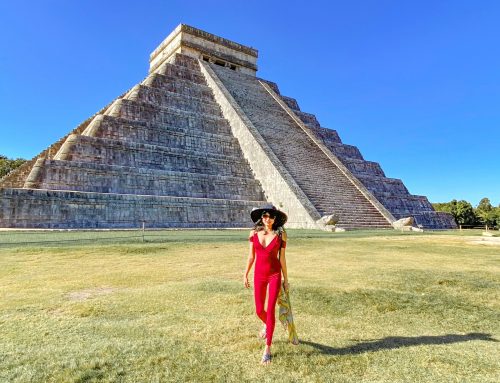
Angkor Wat
The pinnacle of Khmer architecture, Angkor Wat was commissioned by Suryavarman II and completed in 1150, the year of his death. Most temple entrances face east, but Angkor Wat faces west, likely because it was built to serve as his mausoleum. Still, it is a classic temple-mountain in design, symbolic of Mount Meru, with five towers and surrounding walls likened to the mountain ranges at the edge of the Hindu universe. The moat is 200 meters wide and represents the cosmic ocean of the gods.

Angkor Wat, Sunrise
2.6 million visitors come to see the ruins of Angkor every year. Although wooden walkways and additional infrastructure have reduced damages caused by such massive tourism, they are not enough. Some structures are sinking and cracks are widening along temple walls.
Among the many highlights of Angkor Wat are the bas-reliefs covering its walls. They stretch out over 12,000 square meters and include scenes from the Ramayana, homages to the king, and Khmer and Sanskrit inscriptions.

The Churning of the Ocean of Milk
A famous scene in Hindu mythology depicts Ravana, a demon-king who summons the asuras, or demons, and the devas, or gods, to work together on the churning of the ocean to produce amrita, the nectar of immortality.
A period of instability came after Suryavarman II’s death and Angkor was attacked twice by the Kingdom of Champa (present-day Vietnam), sacking the city to the ground in 1177. The following year, Jayavarman VII led an army and ousted the invaders. He was a devout Mahayana Buddhist and had wanted to live a pious life but came out of exile to save the empire. Angkor Wat was restored in the Buddhist tradition. Covering over 402 acres, it remains the largest religious structure in the world and is still a sacred pilgrimage site today.
Angkor Thom
The next capital of the Khmer Empire would be its greatest, but also its last. Built by Jayavarman VII and spread over 10 square kilometers and surrounded by 8-meter laterite walls, Angkor Thom served as the home of the royal court, including his priests and generals. Villages surrounded the outer enclosure, with people living in wooden houses high on stilts, probably similar to traditional Khmer homes today. This was at the height of the empire, and Angkor Thom supported a population of 1 million people.
Ta Phrom
One of the most extraordinary sights in Angkor is the enormous strangler fig and silk cottonwood trees covering Ta Phrom. Although it has undergone extensive restoration, the overgrown jungle is an example of the state in which much of Angkor was first discovered by explorers in the 16th century.

Ta Phrom
Famous as the setting for Tomb Raider, much of Ta Phrom has collapsed under the jungle. The scattered boulders and massive tree roots that cover the ground make it feel like another world.
Built to serve as a university and monastery for Mahayana Buddhism, the rectangular layout sets it apart from the other temple mountains. It was home to over 12,000 people, including 18 high priests, 2,700 court officials, and 800 asparas or royal dancers.
The Bayon
Commissioned to be the state temple, the Bayon comprises 54 stone towers carved with over 200 faces. Some researchers believe the statues represent the bodhisattva Avalokitshvara while others think they are of the king himself as his eyes follow everyone before him. Forever shrouded in mystery, the serene expression on their faces was termed by the French as the “Khmer smile”.

The Bayon
The pinnacle of Khmer sculpture, the Bayon's bas-reliefs stretch over 1.2 km, many depicting wartime and naval scenes from the history of the empire.
Arogayasalas
As a Mahayana Buddhist, Jayavarman VII embarked on a massive building program of public works. In addition to roadside rest houses, he built 102 hospitals. Medical check-ups were offered to all classes of society. A system of hospitalization, treatment and medicine was established. The Arogayasalas had a temple in the center, surrounded by wooden structures housing patients. It was believed that medicinal healing and divine healing went hand in hand.

Leak Neang
Arogayasalas were identically-built temple hospitals. The ruins of 15, out of the 102 built, have been discovered along with Inscriptions of the hospital staff and medicine distributors.
The Khmers kept medical manuscripts at every hospital, cataloging their systems and treatments to be shared throughout the empire and beyond. Their knowledge can be traced back to medical records brought from the Tang Dynasty, as well as Funan merchants and Indian monks who brought books relating to medicine. Some of their treatments, such as using holistic techniques, medicinal plants and herbs, and traditional healing, were later adopted by Europeans.
The Fall
With the rise of Buddhism, the concept of god-king as divine ruler began to wane, undermining the authority of each successive king and making it harder to command the legions of slaves necessary for building their cities.
There is little record for the next two centuries as the empire weakened. Some research also suggests that overdevelopment made it impossible to sustain the growing population. The over-logging and clearing of trees from Kulen Hills likely caused catastrophic floods, damaging the fragile network of canals and reservoirs, destroying farms, and therefore paralyzing trade and agriculture.
The last stone inscriptions in Angkor date to 1431, the same year the kingdom of Siam invaded the already declining empire.

Khmer Inscriptions
Although the ancient Khmer filled their libraries, the books, made of delicate palm leaves, crumbled easily and needed to be recopied. With the empire’s decline, all books eventually disappeared. Only stone inscriptions remain.
Memoirs
In 1296, a Chinese diplomat, Chou Ta-Kuan, came to the imperial city of Angkor Thom. He was welcomed by the royal court and stayed for a year. Clearly in awe, he described its impenetrable walls, magnificent temples, towering monuments and intricate sculptures. He documented the Khmer way of life, from lavish rituals for the king to the everyday habits of common people. Upon returning to China, he published Memoirs of the Customs of Cambodia. It is the only first-hand written account of the empire that has survived.